How the mile travelled to India: Part 2
What circumstances led to the official adoption of the mile in Britain’s Indian empire? And what does this tell us about how ‘standard’ measures travel?
By the mid-1700s, the waywiser (or perambulator) along with the Gunter chain had become an indispensable tool for measuring distance in ordnance surveys conducted by military engineers in Britain and its colonies. As in the metropole, British institutions such as the General Post Office and the military played a decisive role in the establishment of the mile in the East India Company’s newly acquired territories.
But the mile was one among many official measures in use in British India. Colonial authorities in India, as in other imperial territories, incorporated local measures for the purpose of rule. This plurality was politically expedient and reflected the nature of the British colonial state: centralised and military survey expeditions adopted standard British measures, while provincial authorities tasked with the extraction of revenue selectively adopted, and even standardised, local measures that reflected existing forms of knowledge and power in India alongside imported measures.
Milestones for the Post Office
It is 1826 and Captain E. Jeffreys in Calcutta has just learned from the Postmaster General, Colin Shakespeare, that he has been charged with placing milestones from Calcutta, the administrative centre of the EIC’s Bengal territory in Eastern India, to Meerut, near Delhi, roughly 900 miles apart. Jeffreys promptly embarked on this project sanctioned by the Government of Bengal equipped with a perambulator and compass and assisted by European overseers, a local assistant, a chaprassy (attendant), and 12 bildars (labourers), with a government grant that was not to exceed 2 Rupees and 8 annas for each stone laid¹. But while the perambulator was a trusted instrument, Jeffreys had less faith in the ‘exactness’ of measurements of his local assistant. As he wrote to Shakespeare:
‘whilst the Overseer is fixing each stone the duty therefore of the Native Assistant will be to proceed on with the Head Hackery laying the stones as fast as he can by a Perambulator, and as Natives can never be depended upon for exactness unless they know themselves to be looked after, the Overseer must also be furnished with a Perambulator to measure as he follows fixing them.’
Thus measured and marked in red paint in ‘Hindoostanee’ characters by the local assistant and corroborated by the European overseer, 436 milestones were erected along this route at a total cost of 2,144 Rupees and 2 annas to the Bengal treasury. The milestones immediately met with opposition and complaints by influential merchants and village notables over the perceived inaccuracy of the distance measured, with one historian identifying 36 separate instances of milestones being attacked². The Bengal government called upon the police and the courts to protect the integrity of the new measure, though little is known about how these transgressions were punished.
Perambulators and colonial surveyors
Perambulators also served military surveyors of the Company as a less laborious alternative to the chain. The earliest and perhaps most illustrious adopter of the perambulator in India was James Rennell, appointed by the Company as an ensign of the Bengal Engineers and ‘Surveyor of the New Lands’ in 1764. His first assignment was the survey of the Ganges River to identify the shortest navigable waterway leading to Calcutta from the vast northern plains of India. ³
Rennell, who learned the art of surveying as a midshipman of the Royal Navy under the renowned hydrographer Alexander Darlymple, soon proved invaluable for strategic and administrative needs of the new Company state that had just acquired tax-collecting rights (diwani) from the Mughal Emperor. He was promptly appointed the Surveyor General of Bengal in 1767 with the rank of Captain by Lord Robert Clive (then Governor of Bengal and yet to achieve infamy). Accompanied by military officers and sepoys and aided by a quadrant, compass, and copy of the East India Pilot for bearing, Renell conducted ‘route surveys’ using a perambulator and chain for the next nine years, with the express purpose of determining paths for the march of Company troops and other ‘political missions’.
These surveys were then compiled into compendiums of five-miles-to-an-inch maps at his headquarters in Dacca (now Dhaka in Bangladesh). His Book of Roads in Bengal and Bahar (1778) served as a description of roads emanating from the principal trading cities of Calcutta, Murshidabad, Patna, and Dacca, measured in miles and intended for Company servants (Fig. 1). Like Ogilby’s Britannia a century ago, Rennell’s roads also contained descriptions of rivers and nullahs, fords, and ferries, but without recourse to pictorial depictions. ⁴
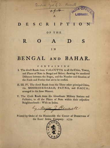
Figure 1: James Renell’s Book of Roads in Bengal and Bahar (1778) printed as A Description of the Roads in Bengal and Bahar in 1779 by the order of the Court of Directors of the East India Company. Renell recorded distance in miles and furlongs.
Inspired by French cartographers before him, including French Jesuit geographers in India, Renell published a detailed map of Bengal in his Bengal Atlas in 1780, followed by the Map of Hindoostan in 1782 (Fig. 2). His work received much acclaim in London, earning him election as a Fellow of the Royal Society. Later in life he was involved in the planning and promotion of the Royal Geographical Society and in 1930 was officially recognised as one of its founders.
Similar surveys were also being undertaken in South India, the most notable being Thomas Barnard’s 1767 survey of the Chingleput District in Madras ceded by the Nawab of Arcot to the Company, and Colonel Colin Mackenzie’s survey of the Kingdom of Mysore beginning in 1799 (Mackenzie would go on to become the first Surveyor General of India in 1815).
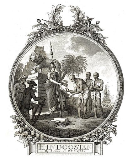
Figure 2: A cartouche in James Rennel’s Map of Hindoostan whose caption reads ‘Britannia receiving into her Protection, the sacred Books of the Hindoos, presented by the Pundits, or Learned Bramins: in Allusion to the humane Interposition of the British Legislature in Favor of the Natives of Bengal, in the Year 1781.’ The public presentation of cartography served to legitimise empire by enlisting local forms of knowledge and authority – and particularly that of the higher castes – in the colonial mission to civilise ‘Native’ society through commerce and enlightened administration.
Colonial surveyors since Renell continued to use the perambulator to produce maps scaled in miles in India (Fig. 3). Imported perambulators, however, proved inadequate to the task at hand. As one official put it:
‘All English perambulators are flimsy, bad in principle, and incapable of working except on a smooth road or bowling green; across country they go to pieces in a mile or two.’
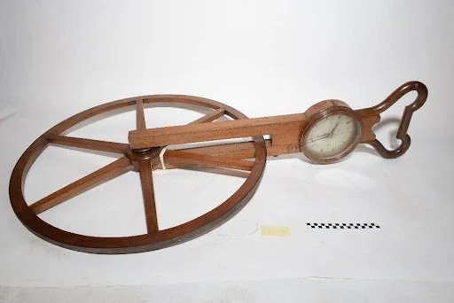
Figure 3: Waywiser, by Cary, London, c. 1800. HSM Inventory Number 55468. Perambulators of this type proved ineffectual on Indian terrain.
Responding to the constant breakdown of the perambulator, John Pringle, soldier and surveyor in Madras, devised a sturdier instrument during the Anglo-Mysore Wars in the late 1700s. Pringle’s new perambulator was seven feet wide in diameter and made of iron wheels fitted with differential brass axle plates, requiring two men to operate it (Fig. 4). Its dial recorded the revolutions in miles, furlongs, feet, and inches. Pringle established a military Corps of Guides which conducted surveys in Madras for the next thirty years making ample use of his innovation. The ‘Madras Pattern Perambulator’, as Pringle’s device came to be known, proved popular, even finding limited use in revenue surveys across India. Over the course of the next century, surveyors manufactured different versions of the perambulator adapted to local terrain, including the waywiser devised by George Everest and Seid Mohsin Hussain for the Great Trigonometrical Survey.

The Madras-pattern perambulator designed by John Pringle and used by surveyors in India
The perambulator and the mile thus followed the institutions of the British state in imperial territories, but their dominance was far from total. Local measures such as the ‘kos’, ‘gaz’, ‘bigha’, ‘gajam’, and ‘adee’ were selectively used by early military surveyors in India in addition to the mile as local informants produced charts in units that were familiar to them (Fig. 5). Other linear measures such as the anthropomorphic ungoolum (the distance between the thumb joint to the tip of the nail) or the syncretic Tamil measure nauzhivazhy (the distance that could be covered by foot in 24 English minutes, seven of which constituted a caudam) lived alongside the English mile.
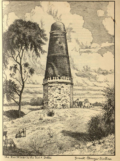
Figure 5: Sketch of a kos minar in Delhi by Frank Scallan. Pashtun Emperor Sher Shah Suri, who ruled northern India from 1540-45, erected thirty-foot towers at a regular interval of a kos (ranging between 1½ to little over 2 miles) along the Grand Trunk Road from the Indus to Bengal, intended to improve travel and communication on this important commercial route. British officials who later encountered these towering artefacts (which can be found to this day), marvelled at the emperor’s ambition, but found the kos to vary from province to province. Changes in the landscape and roads rendered these towers less accurate over time.
Meanwhile, the colonial revenue state adopted a distinctly Anglo-Indian lexicon of measurement, combining local measures of length, weight, and capacity with British ones, a system they attempted to codify in various Weights and Measures Acts in the nineteenth and the early twentieth century. Nor were perambulators the only tool used to measure distance, with colonial surveyors adopting methods such as pacing, where a human (a ‘moonshee’) constituted the measuring instrument, a method used in the Trans-Himalayan survey. Local and subjective notions of distance and time thus combined with mathematical instruments and imported measures to produce enforceable standards of territory and property.
Renell’s warning that ‘unless all the measures of the different regions were reduced to a uniform standard it was not possible to figure out the relative size of each of the regions’ was thus heeded partially and selectively by the colonial state. Indeed, the enforcement of standard measures depended on circumstances far beyond the surveyor’s control, such as the relationship between the state and its various subjects, the nature and extent of commerce in a region, and forms of social ordering such as caste. But as Renell knew, this was far from unique to India, for ‘the mile’ he observed varied ‘much more in their proportions, in the different parts of Europe’.
¹ The rupee, a silver coin, was the currency of India, pre-dating the British and adopted by the Company. One anna was 1/16th of a rupee.
² Biswas, ‘Precarious Measures and Precise Numbers’.
³ An ensign was the lowest rank of the officer corps, with lieutenant, captain-lieutenant, and captain above it.
⁴ A nullah is an intermittent watercourse, a gully, or a ravine.
References
James Renell, A Description of the Roads in Bengal and Bahar (1779).
R. H. Phillimore, Historical Records of the Survey of India Vols 1-4 (1945-58).
G. F Heaney, ‘Rennell and the Surveyors of India’, The Geographical Journal, Vol. 134, No. 3 (1968), pp. 318–25.
Kapil Raj, ‘When human travellers become instruments The Indo-British exploration of Central Asia in the nineteenth century’, in Marie-Noëlle Bourguet, Christian Licoppe and H. Otto Sibum (eds.), Instruments, Travel and Science Itineraries of precision from the seventeenth to the twentieth century (Routledge, 2002).
Paulami Guha Biswas, ‘Precarious Measures and Precise Numbers: Fixing the Milestones in Early Colonial Eastern India’, Economic and Political Weekly, Vol. 52, No. 4 (2017), pp. 43-50.
Baijayanti Chatterjee, ‘Founding Empire: James Rennell and the Eighteenth-Century Survey of British Bengal’, XVII-XVIII 78 (2021).
U. Kalpagam, ‘Colonialism, Rational Calculations and Idea of the 'Economy'’, Economic and Political Weekly, Vol. 32, No. 4 (1997), PE2-PE12.
Links to our Collection
Waywiser, by Cary, London, c. 1800. HSM Inventory Number 55468
Everest Pattern Waywiser, by Seid Mohsin, Masuri, 1833 Inventory Number 42112
