Seid Mohsin and the Everest Pattern Waywiser
In October 1833, George Everest, the Surveyor General of India and Superintendent of the Great Trigonometrical Survey, sent out from his station in Mussourie in the foothills of the Himalayas a set of two differential wheels of a waywiser with the following missive to his Chief Computer, Joshua DePenning, in Calcutta¹:
‘I wish to be engraved on the inner wheel on the three radii...emanating from the centre — "Differential perambulator — Designed by Major Everest — Executed by Seid Mohsin". On the radii of the outer wheel — "Fore wheel shows thousandths — Back wheel miles and tenths — Masuri, 15th October 1833". If all these inscriptions cannot be compressed on the radii, so as to be done cleverly, each in one line, let them all be omitted, and send the wheels back with only the figures. I know, if any can manage it, you are the person.’
Everest, proud of his innovation, submitted two copies of the engraved dials to his superiors: one to the Governor General of India, Lord Auckland, and the other to the Commander-in-Chief of the Indian Army, Sir Jasper Nicolls. This dial, bearing Everest’s inscription, is now housed in the History of Science Museum (Fig. 1). It is unclear which version of the waywiser dial wound its way to Oxford.

Figure 1: ‘Everest Pattern Waywiser, by Seid Mohsin, Masuri, 1833’. HSM Inventory Number 42112.
This waywiser dial is unique in HSM’s collection of mathematical instruments in being identifiably an object made in colonial India. It is also exceptional in disclosing the identity of its maker, Seid Mohsin, in a period when such attributions to artisans in India was altogether rare.
Who was Seid Mohsin, and why did Everest insist on inscribing his name on the waywiser?
To answer this, we turn to how the Great Trigonometrical Survey worked in practice. The survey, as we will see, combined different traditions of knowledge: from Mughal-era courtly metalworking and sixteenth century European practical surveying, to contemporary geodesy. This was a world where artisanal expertise and knowledge was central to the production of ‘science’, and where ideas of cartographic enlightenment of colonial officials came up against the realities of physical geography, hierarchies of labour, malfunctioning instruments, and the financial strains of maintaining and measuring its largest empire.
George Everest and the Differential Perambulator
Trained in the Royal Military College in Marlow and the Royal Military Academy at Woolwich, George Everest joined the East India Company as a cadet in 1806 shortly before he turned sixteen (the minimum mandated age for recruitment). Following brief stints in the Bengal Artillery and a military secondment in Java, Everest caught the eye of Colonel William Lambton, leader of the Great Trigonometrical Survey of India, who appointed him Chief Assistant in the survey. Everest would go on to succeed Lambton as the Superintendent of the GTS in 1823, also assuming the role of the Surveyor General of India in 1830 (Fig. 2). His contributions to geodesy and surveying in India would be commemorated by his successor, Andrew Scott Waugh, who christened Peak XV, the highest recorded mountain by the GTS, ‘Mount Everest’ (Peak XV did, however, have several contemporary appellations in Nepali and Tibetan that colonial officials and the Royal Geographical Society with their penchant for discovery chose to overlook).
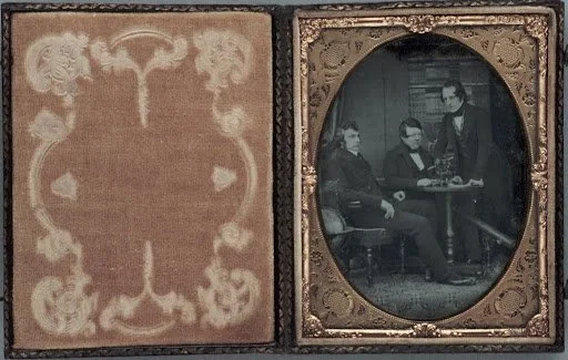
Figure 2: Photograph (Daguerreotype) of Sir George Everest and Two Other Men with Scientific Instruments, c.1850. HSM Inventory Number 94483.
Everest, the ‘practical geodesist’ with command over contemporary theory and the latest advances in Ordnance Surveys in Britain and Ireland, was also an able administrator. He is credited with numerous improvements in the practical procedures of the survey, including technical and organisational innovations in the field, and the recruitment and training of officers and skilled workmen in the arts of surveying. Everest’s method of triangulation using the ‘grid-iron frame’, which resulted in great savings in time and money for the Company, is discussed in another post. Here I would like to draw attention to another of Everest’s key innovations, the ‘Ray Trace method’.
In flat plains, such as the vast Jamuna floodplains in Northern India, obstacles prevented a clear line of sight between stations, rendering theodolites and base towers useless. To overcome this difficulty, Everest devised a method of minor triangulation using a traverse or route survey between two mutually invisible points aided by light signalling. For short traverses, this involved the use of a modified (‘reverberatory’) lamp and a perambulator by the surveyor, the latter adapted by Everest for this purpose (Fig. 3). The measuring wheel was made heavy so that, in Everest’s words, ‘it may be pleasanter to the native who conducts it on the ground than to carry it on his shoulder’. The design was also intended to cheapen the cost of perambulators to the Government by producing it within the country (the initial models were manufactured in a government-owned Gun Carriage Factory).
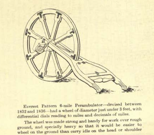
Figure 3: Illustration of an ‘Everest Pattern 6-mile Perambulator’ devised by George Everest between 1832 and 1836 to conduct route surveys for the Great Trigonometrical Survey.
Aside from the structural deficiency of the English perambulator, a deeper problem lay in the measures it utilised, which consisted of older units that were difficult to translate to conventions then in use in Indian map-making. As Everest observed:
‘Our maps are constructed in miles and decimals of miles...but the dial plate of the present perambulator shows miles, furlongs, poles, and yards, and we must go through a tedious process of reducing to decimals of a mile. Since a mile is 5280 feet, I propose that the long hand shall revolve one when the wheel has been trundled over 528 feet of ground.’
Everest thus devised a system of differential wheels modified from the existing Madras-type perambulator but adapted to measure in miles and decimals of miles. The adaptability of the waywiser was appreciated by fellow surveyors, particularly revenue surveyors burdened with the official decision to use the ‘acre’ as a standard area measure in a country where local measures (such as the bigha, gaz, or hath) were still in use. Everest lamented that he ‘could never bring my mind to what the acre has to do with India. Its introduction appears to involve a cumbersome system where simplicity is a great desideratum.’
By Everest’s own admission, while the design of the waywiser was his, it was Seid Mohsin – the ‘Native Artist’ in official parlance – who executed it, bringing to life the intricate division of the measuring dial and its differential wheels.
Seid Mohsin Hussain: The artist from Arcot
Said Mir Mohsin Hussain was a blacksmith and carpenter, hailing, it was said, from a ‘good family’ with connections to the Nawab of Arcot. Early in the 1800s, Mohsin worked for George Gordon, a reputed Madras-based jeweller with roots in the Aberdeen silversmithing trade (Fig. 4). Around this time, Mohsin appears to have engaged in work at the Quartermaster General’s office in Madras. Here he came under the notice of Colonel Valentine Blacker, then the Quartermaster General of the Madras Army, who brought him to Calcutta in 1827 to carry out repairs and maintenance of surveying instruments under the Surveyor General’s office. Mohsin reportedly earned Rs. 35 for his troubles, familiarising himself with astronomical observations and instrumentation.

Figure 4: Embossing of the initials of George Gordon & Co. on a piece of silverware. Mohsin worked in this Madras firm with roots in the Aberdonian silversmithing trade.
It was in the Calcutta workshop in 1830 that Everest first encountered Mohsin and immediately took a liking to him over the official Mathematical Instrument Maker of the Survey, Mr. Henry Barrow:
‘I found him in Calcutta in 1830, little prized by anybody, deeply regretting his former kind patron [Blacker], and half disposed to return to his native country, and I was not long in perceiving the distinguished qualities which marked the Seid. The irritable tendency of Mr. Barrow rendered it prudent to make myself as independent as I could of his services, and so early as 1832, when this cross-grained person was under his periodical fit of perverseness, I was enabled to construct the most delicate parts of the complicated apparatus for comparing bars or chains without his aid, through that of Seid Mohsin.’
Everest conceded that Mr. Barrow was a ‘skilled workman’, yet he was ‘really not so expert as Seid Mohsin’, who in any case was more adept in conveying instruments on the march and repairing them in the field, whereas Barrow was concerned with ‘his own particular business’. In a damning assessment, Everest concluded: ‘Mr. Barrow was about as completely helpless as need be.’
Mohsin was soon recruited by Everest at a monthly salary of Rs. 90 to aid in his survey operations in Saugor (Sagar, in present-day Madhya Pradesh in Central India) and Agra (a city on the banks of the Yamuna River in present-day Uttar Pradesh) in 1832, followed by the field office at Garmucktesar (Garhmukteshwar, a town by the Ganges in present-day Uttar Pradesh) and the workshop at Hathipaon (in Mussoorie). Mohsin’s contribution to the survey proved invaluable, with Everest recommending him to a post of Sub-Assistant in 1836, observing that he was ‘peculiarly remarkable for his inventive talent, the facility with which he comprehends all mechanical arrangements, and the readiness with which he enters into all the new ideas of others. Without the valuable aid rendered to me, it would have been utterly out of my power to carry into effect my various projects for the remodelment of the instruments.’

Figure 5: Signature of Seid Mohsin in English and Urdu. Below ‘Maths. Instr. Maker’. Mohsin was appointed the Mathematical Instrument Maker of the GTS by the East India Company, replacing Henry Barrow.
Mohsin’s duties ranged from the effective re-working of survey instruments in the field, the devising of new implements (such as Everest’s reverberatory lamp), the maintenance and repair of worn instruments and baseline apparatus (including clocks and watches), the careful and skilled division of horizontal circles of astronomical instruments (a ‘crowning triumph’ according to Everest that even Barrow refused to touch), to the training of junior artisans in the survey team and the smooth running of field workshops. Mohsin, Everest observed with some degree of astonishment, ‘understands all the instruments, and I entrust to him to take the largest, most complicated, and most delicate parts entirely to pieces with the utmost confidence’, leading him to conclude that ‘he has both genius and originality; his conduct is marked by the highest probity, and he is one of the few on his word I could place entire reliance.’
How instruments travel
Instruments fall into constant disrepair as they travel. Nineteenth century survey instruments, valued for their stubborn precision, were fragile and prone to variability in challenging terrain, and the networks sustaining them from London to up-country India were liable to fray. Possessing the resources to calibrate, maintain, repair, and re-interpret the working design of tools in the field was crucial to any measuring exercise conducted away from their point of manufacture. The reproducibility of a ‘standard’ measure thus depended on a precarious material edifice.
And so it was with the Great Trigonometrical Survey: while survey instruments were shipped in from London, there was a desperate need for skilled workers proficient in the art of maintaining mathematical and astronomical instruments in working condition closer to hand. Mohsin’s centrality to the Great Trigonometrical Survey can be seen in this admission by Andrew Scott Waugh, the Surveyor General of India:
‘Astronomical instruments are even more delicate and more likely to get out of order…besides which in travelling over a journey of 400 miles and upwards, over wide and stony roads, they are exposed to more and greater accidents. Now, if a screw were to get loose, or any like accident arise in one of the mural circles at Greenwich, that instrument would only be powerless until the coach from Charing Cross had brought up Mr. Simms, or Mr. Jones, or Mr. Dollond, armed with all the skill and appliances of London workmanship. But in our case, if a screw were to get loose, not only would the instrument lie idle till repaired, but the other instrument operating at 400 miles from it would likewise be rendered null. The only safeguard is to send Seid Mohsin to Kalianpur and back by dak [mail train], for which authority may be granted to incur the expence.’
Everest was by now growing increasingly frustrated with Mr. Barrow, who was not beyond taking credit for the work of the ‘native artist’. As Everest complained:
‘It is to Mir Mohsin that I am indebted for the completion [in 1832] of the apparatus for comparing the chains and the standard bars. The 18-inch theodolites by Cary both required to be remodelled. When indeed Mr. Barrow found that my plan was prospering, he offered to take the completion in hand, on which, when they were ready, I found his name engraved, without any mention of the native artist, although he had no share whatever in the design, which was mine throughout, or in the construction of any of the parts which were new, and then first practically applied by Mir Mohsin.’
Recognising Mohsin’s importance to the survey, Everest made a reference to the Directors of the East India Company to accept Seid Mohsin as a fit successor to Barrow as Mathematical Instrument Maker. He left the decision of Mohsin’s salary to the Government of India, but recommended Rs. 350 per month as ideal compensation (Barrow, by comparison, earned a handsome Rs.1,000). Government ordered that Mohsin should be stationed at Calcutta with a monthly salary of Rs.250 and designated ‘Head Artificer in the Department of Scientific Instruments.’ An additional £200 was bestowed on Mohsin for his work on the dividing circles. Everest vehemently protested the terms of his employment, which he considered ‘unworthy’ of Mohsin and ‘a source of deep mortification to him’, so that in 1843 the Directors ordered that Mohsin be appointed the Mathematical Instrument Maker of the Great Trigonometrical Survey, perhaps the first Indian-born artisan to achieve this high a standing in an official department.
The artisan and science
Everest’s insistence on Mohsin’s contribution to the waywiser should be viewed in light of this episode, one that illuminates the class and racial hierarchies that structured survey operations and its bureaucracy. This story also reveals the many ways of knowing that coalesced in the production of modern geodetic knowledge. Mohsin’s background in silversmithing and carpentry proved invaluable in the modification and maintenance of survey instruments. But this was no coincidence. Nineteenth century geodesy was built on these other ways of knowing, foremost the artisanal working of wood, metal, glass, and precision in dividing circles, a heritage that can be gleaned in the great contemporary artisanal firms of England producing mathematical and astronomical instruments.
In India too, this legacy would prove important. George Gordon & Co., the Aberdonian silversmithing firm in Madras which employed Mohsin, partnered with Scottish watchmaker Peter Orr and his brother Alexander, a lawyer (both previously engaged in the ice trade in Madras). The brothers would eventually take over the now distressed firm in 1849, rebranding it as P. Orr & Sons. Some measure of their success can be inferred from their patrons, which included the Nizam of Hyderabad and the then Prince of Wales, Albert Edward (later King Edward VII). Their iconic showroom in Mount Road, Madras City (Fig. 6) was inaugurated in 1879 by Prince George, Duke of York (later King George V) and Princess Mary of Teck (later Queen Mary).

Figure 6: P Orr & Sons showroom in Anna Salai, Chennai (formerly Mount Road, Madras). Photo by author, May 2026.
In addition to clocks and watches, and what became renowned in Europe as ‘Swami Silver’ (the rendering of Hindu religious iconography using European metalworking techniques in gold, diamond, and silver), P. Orr & Sons were official agents of Cooke, Troughton & Simms in India, the foremost suppliers of mathematical and astronomical instruments in India, and indeed, globally (Fig.7).

Figure 7: Advertisement for a Surveyor’s Level (S. 300) by Cooke, Troughton & Simms Ltd. by their official supplier in India, P. Orr & Sons. Undated.
In 1902-03, the Madras firm reportedly employed over 600 artisans, some of them engaged in the production of scientific instruments and armoury, though this remained secondary to their watchmaking and jewellery business (Fig. 8).
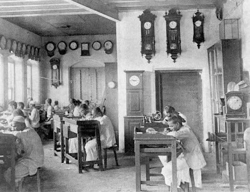
Figure 8: P. Orr & Sons, Madras, c.1875
Mohsin’s rise within the ranks of the Great Trigonometrical Survey was extraordinary for an artisan in nineteenth century India. The conditions of this exception reveal much about the hierarchies that structured knowledge-making in colonial India. What was far from exceptional, however, were the eclectic ways of knowing and making, far removed from the idea of science conducted in a laboratory, that made nineteenth century geodetic surveys possible.
¹ The term ‘computer’ here refers to a person who performs mathematical calculations. Human computers were an essential part of the GTS, performing computations, often logarithmic calculations, based on the data received from the field. These computations formed the basis of the maps that were produced by the survey.
References
Cooke, Troughton & Simms, ‘Surveying Instruments and Allied Apparatus’, 1930. History of Science Museum Archive.
R. H. Phillimore, Historical Records of the Survey of India Vols 3-4 (1945-58).
Elizabeth Baigent, ‘Everest, Sir George (1790–1866) geodesist and military engineer’, Oxford Dictionary of National Biography (Oxford University Press, 2008).
Simon Schaffer, ‘Easily Cracked: Scientific Instruments in States of Disrepair’, Isis,Vol. 102, No. 4 (2011), pp. 706-717.
James A. Bennett, The Divided Circle: A History of Instruments for Astronomy, Navigation and Surveying (Phaidon Christie's, 1987).
Janane Venkatraman, Anusha Parthasarathy, ‘Survivors of Time: P.Orr & Sons — Timekeepers of Madras, since 1849’, The Hindu, 13 December 2012.
Links to our Collections
‘Everest Pattern Waywiser, by Seid Mohsin, Masuri, 1833’. HSM Inventory Number 42112.
